A Day in the Life of a PCT Thru-Hiker: NorCal Edition

In 2019, there were hella high levels of snow in the Sierra Mountain Range. The snowpack was at 176%, which left us Pacific Crest Trail thru-hikers with a difficult decision to make: do we try to hike through the Sierra or figure out another option? Eventually, Tuna Butter and I settled on skipping 400 miles north into Northern California. This blog post picks up after that skip. You can learn more about what went into that decision-making process in our previous post “To Hike, Flip, Skip or Quit in the Snow Sierra?

We jumped north into Truckee, California and set off on the PCT from Donner Pass (Mile 1157). We made the skip with a trail friend named Fish Addict. After a bus and a hitch, we set off in the early evening of the Summer Solstice.

Mt Shasta and Calypso in conversation. Photo by Amos Almy.

Day 1

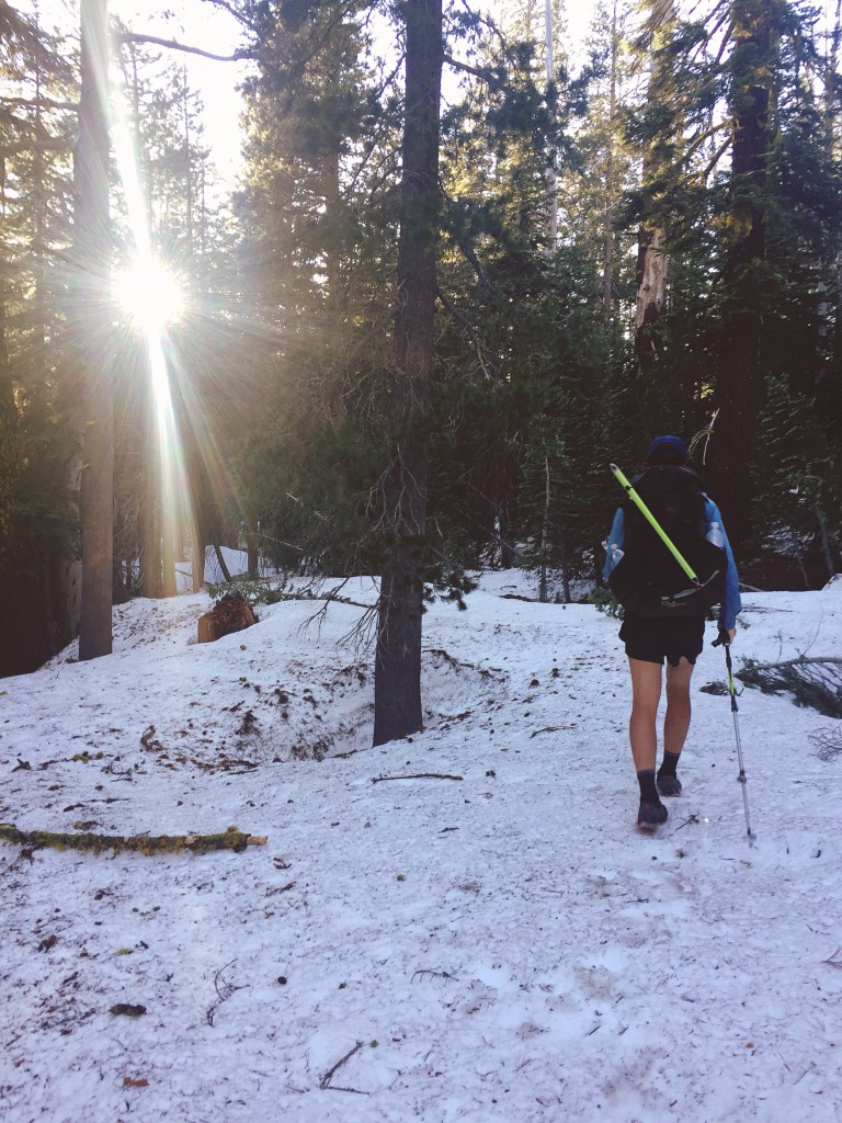
It was inevitable that we’d hit snow. We were hiking this section earlier in the season than most thru-hikers. Because of this, we came prepared with our ice axes and microspikes. On a normal year, these items would be unnecessary for this section, but we were glad to have them.

Our original plan for day one was to stay at a hut on trail – one of the few rare ones along the entire PCT. We left Donner Pass separately from Fish Addict, fully intending to meet up that night. Right away, we were walking on several feet of snow. It was a pain to navigate through the thick forest with no trail markers. The GPS on our phones came in handy, as well as our own intuition. Surprisingly, we crossed paths with a SOBO (southbounder) who informed us that the Sierra Club had rented out the hut for the night and were not letting thru-hikers stay there, which was a major disappointment.

Instead, we found a spot to sleep on an exposed ridge. It was super windy but miraculously snow free. We texted Fish Addict with a plan to meet up the next day. Tuna Butter hardly slept that night and kept worrying that the wind would rip apart our tent. Fortunately, that didn’t happen (thanks Big Agnes!).

In the morning we passed the hut full of Sierra Clubbers, all warm and snuggly by their wood stove. I, Calypso, tried not to feel envious as I wore all of my warm layers to hike.

Continue reading

To Hike, Flip, Skip, or Quit in the Snowy Sierra?

It’s not every year that you have to think about your options for the Sierra. But sometimes, the Sierra Mountain Range gets pummeled with snow and it does not melt away until late July or August. This can make for a difficult decision for a thru hiker. 

When we started the trail (and probably like most thru hikers) we believed we would walk from one border of a country to another: Mexico to Canada. Our intention was to hike a single footpath covering 2650+ miles. We would not call ourselves “Purists”, and most hikers probably wouldn’t either, but there is an inherent attraction in hiking from a place to another in one continuous line – South to North, or North to South. So, as we neared the end of the desert section, we started analyzing our options for the foreboding Sierra Mountains ahead. Here is a bit of our thought process.

This is a little confusing but compare the green line (2019 snow) to the black line (average).

The Sierra were at 176% for their snowpack. That means it was 76% above normal, leaving us and many hikers in a bit of a pickle. Here is a peek at the back and forth that happened frequently among us:

“That snow is going to make navigation really tough.”

“Ya but how bad can it really be? We have Guthooks (navigation app) and paper maps.”

“Have you seen the pictures of people going over Forester Pass?!?”

“Ya but that was like 2 weeks ago, it should be better by the time we get there.”

“What about the raging river crossings?”

“Well, that’s just a part of hiking the PCT! We will be smart about it.”

“But what about the fact that I’m 5’3, pint-sized, and not a very good swimmer?” (Maybe more relevant to Calypso than others).

And you go on and on, trying to justify entering this no-joke of a mountain range. Remember, the trail takes you up to 12,000-14,000 feet in elevation. It’s tricky to make the decision by crowdsourcing, even if you talk to previous thru-hikers. The constant advice you will receive from others is “hike your own hike, man”. Which is good advice but you still have to figure out how to hike your own hike…man.

What the trail looked like heading out of Truckee, CA

Here are some options we had to consider:

  1. Hike through the Sierra, no matter the conditions.
  2. Wait a few days, then a few more, maybe a week or two, and then hike through the Sierra.
  3. Flip-flop (jump ahead and hike back in the opposite direction).
  4. Skip the Sierra, keep hiking north, and return after reaching Canada.
  5. Leave the trail and save it for another year. 
Continue reading